
Multiple Wildfires in the Inland Empire: Juniper Fire Erupts in Riverside County, Triggering Evacuations as fast-moving flames spread across Southern California. Firefighters race to contain multiple blazes while residents face urgent evacuation orders.
Firefighters Battle Three Blazes East of Los Angeles
It started like any other hot summer morning in Riverside County. But by noon, the skies were orange-gray as smoke from the Juniper Fire blanketed the sky. Residents of Perris, already used to wildfire season, were once again forced to flee, as one of three major blazes east of Los Angeles rapidly spread.
As firefighters battled three blazes east of Los Angeles, including the Juniper Fire, thousands faced evacuation, and emergency crews raced to contain the rapidly growing flames. The threat was real, the flames were fast, and the Inland Empire braced for impact.
Firefighters Battle Multiple Blazes Across Riverside and San Bernardino Counties
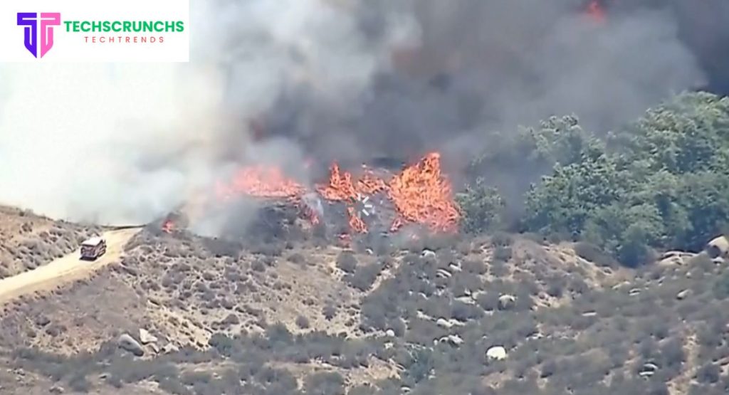
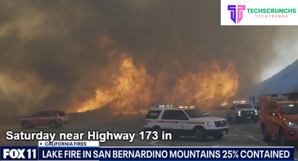
The Inland Empire faced a weekend of chaos as six wildfires ignited across Riverside and San Bernardino Counties. These included the fast-spreading Juniper Fire, the massive Wolf Fire, and the stubborn Lake Fire, all demanding the full attention of first responders.
Here’s a snapshot of the fire activity:
| Fire Name | Location | Size (Acres) | Containment |
|---|---|---|---|
| Juniper Fire | Perris, Riverside County | 688+ | 90% |
| Wolf Fire | Near Banning, Riverside County | 2,414 | 40% |
| Lake Fire | Silverwood Lake, San Bernardino | 489 | 70% |
| Mindy Fire | Aguanga, Riverside County | 109 | 98% |
| Mandalay Fire | Riverside, CA | 83 | 100% |
| Smiley Fire | Redlands area | 83 | 100% |
Juniper Fire Erupts in Riverside County, Triggering Evacuations
How the Juniper Fire Started
The Juniper Fire was first reported at 11:27 a.m. on June 30, 2025, near Idaleona Road and Juniper Road in unincorporated Perris. High heat, dry grass, and wind helped it swell to over 689 acres in just a few hours.
Fire crews from Cal Fire were dispatched immediately, and air tankers and helicopters took to the skies. Though the spread was temporarily stopped by 6 p.m., the fire was only 10% contained, prompting widespread evacuation orders.
Evacuation Zones
Evacuation Orders – RVC-1059 Zone:
- North of Rocky Hills
- West of Forrest Road
- East of El Nido Road
- South of Orange Avenue
Evacuation Warnings – Surrounding Zones:
- RVC-1060
- RVC-1170
- RVC-1172
- RVC-1173
- RVC-1273 A & B
You can find an interactive map and updated status on Cal Fire’s evacuation site.
Emergency Shelter and Road Closures
A Care & Reception Center was opened at Citrus Hill High School, Perris, to assist evacuees. Santa Rosa Mine Road between Juniper Road and Post Road was also closed for public safety.
What Makes These Fires So Dangerous?
Fire officials cite California’s unusually dry winter, above-average heat, and dense grass growth as key contributors to the outbreak. According to the National Interagency Fire Center, Southern California faces above-normal fire potential through September.
And with more people living near wildland-urban interfaces (WUIs), the danger is compounded.
Why the Inland Empire Is a Fire Risk Zone
The Inland Empire’s mix of urban sprawl and dry open land makes it a hotspot for fast-moving fires. As communities push into fire-prone areas, the risks grow:
- Flammable vegetation near homes
- Limited evacuation infrastructure
- Difficult terrain for emergency access
For areas like Perris, this means residents must act quickly when fire strikes.
Step-by-Step Guide: How to Stay Safe During Wildfires
1. Stay Updated
- Subscribe to Cal Alerts
2. Pack a Go-Bag
Must-haves:
- Medications, IDs
- Chargers, water, food
- Extra clothes, pet supplies
3. Make a Family Plan
- Choose a meet-up location
- Know multiple evacuation routes
- Share plans with relatives
4. Create a Defensible Space
- Clear 100 feet of brush around your home
5. Evacuate Promptly
- Don’t wait for second warnings
- Head to designated shelters or safe family homes
Inside the Blaze: Stories from the Ground
One San Bernardino firefighter described the Juniper Fire as “a wall of heat and wind that just didn’t stop.”
“We saw flames overtaking fields in minutes. We had to knock on doors and plead—‘you have to go now.’”
Maria Lopez, a Perris local, added:
“We didn’t think it would come our way. Then we saw helicopters and a firefighter yelling, and we were gone within 10 minutes.”
A Pattern of Destruction: Is California’s Fire Season Getting Worse?
The numbers say yes. According to Cal Fire data:
- 2020: Over 4.3 million acres burned
- 2022–2023: Mild years (~300,000 acres each)
- 2025: Forecasts show above-normal fire activity
The increased frequency and intensity of wildfires align with broader climate change trends, making proactive preparedness crucial.
After the Flames: Preparing for the Next One
The Juniper Fire and its neighboring blazes are a sobering reminder: in California, wildfires are a year-round threat. Whether you’re a resident, a public servant, or a concerned friend, preparation makes all the difference.
Be proactive. Be informed. And never wait when evacuation orders come—seconds can save lives.

